BirdScan MR1
The compact radar system for quantitative research on aerial fauna
The bio monitoring systems measures the bird and bat movement using a rotating horn antenna. In addition to the analyses of the spatiotemporal distribution, the system offers real time classification and quantification represented as mean traffic rate. Data are stored in raw format and is available for further processing.
General description
BirdScan MR1 is a compact radar system for the quantitative long-term monitoring of birds and bats. It uses a vertically directed conically shaped wide aperture beam with a nutating movement. This setup allows to record a rich set of information for each target:
- Precise recording of target’s height above ground.
- Wing flapping pattern which is necessary to exclude non-bird and non-bat echos like insects and allows classification of bird echos into sub-groups.
- Precise knowledge of surveyed volume which is necessary to estimate the number of birds aloft per volume, i.e. to compute Migration Traffic Rate for specific altitude layers (birds / horizontal km * hour).
- Flight direction and speed of target is obtained from the nutating beam.
- Shape of target (long vs. round) is obtained from circularly polarized beam.
- X-band radar which can detect even small birds (e.g. small passerines) and bats up to 1000 m and large birds (e.g. gulls) up to 2000 m.
- Bio monitoring of birds, bats and insects. (read more about bats in this article)
Comparison to traditional bird-radars
Traditional horizontally or vertically rotating bird-radars only illuminate a target for a fraction of second and wing-flapping pattern cannot be recorded. Therefore non-bird echos like insects cannot be properly excluded. In traditional rotating radars the surveyed volume is generally not well-defined and therefore computation of MTR is problematic.
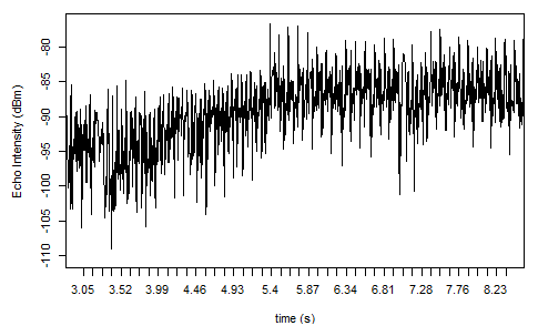
Example of echo from a bird recorded by MR1 system
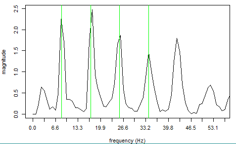
The wing-flapping pattern is recorded and can be extracted automatically, here a continuously flapping bird with 8 wing-beats per second.
Characteristics in detail
Birds and bats are detected using pulsed radar that emits beams vertically across a conically-shaped field from a corrugated Horn-antenna with a wide aperture angle. BirdScan consists of a transmitter/receiver unit and a computer and analysis unit. The system can be monitored remotely if connected to the internet.

Placement
Wind turbines
The MR1 radar can be placed as close as 150 m to a turbine with a height of 90 m (hub height + rotor radius). Like for any radar, a rotating blade within the measurement range would produce strong disturbances and would make it hard to properly detect all birds. Generally, it is advisable to keep a distance of at least twice the height of the windturbine.
Offshore deployment
The offshore version of the BirdScan MR1 replaces some components with more robust parts in order to withstand offshore conditions. This version can be deployed offshore on a platform.
High quality offline-analytics
BirdScan MR1 radar systems can reliably detect even small passerines and small bats. Hundreds of thousands echos per month can be recorded. To leverage the full potential of this data, our experts can provide detailed off-line analytic services to crunch the data and deliver high quality analyses and reports for impact assessment reports or scientific publications. A few examples of display items are shown in the following illustrations:
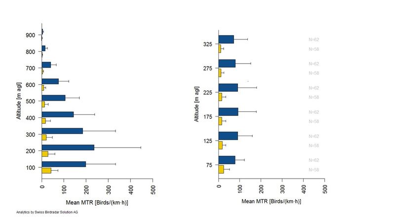
Precise estimation of altitude
BirdScan radar systems provide a precise estimation of altitude above ground of each detected bird or bat allowing to compute Migration Traffic Rate for specific altitude layers. Here standard altitude of 100 m (left) or 50 m (right).
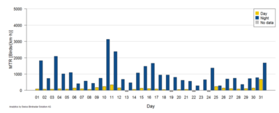
Migration traffic rate per day
Based on onset of dawn and dusk, the Migration Traffic Rate can be computed on a per day basis. Here for altitudes in 50 – 1000 m. Custom altitude and time resolutions are also possible.
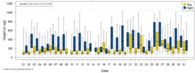
Time and height migration profile
Detailed time*height migration profile. For each day and each night altitude distribution is plotted as box-plots. This allows a detailed assessment of collision risks at specific heights.
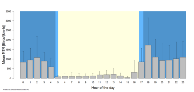
Per-hour mean MTR
Per-hour mean MTR can be computed from seasonal or monthly data. Relevant information can be plotted jointly (herelight/dark periods).
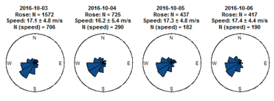
Detailed flight direction profiles
Thanks to its slight rotation, MR1 can measure the flight directions of individual birds and bats. This allows to derive detailed flight direction profiles. In this example for four consecutive nights.
Functionality of BirdScan MR1
Product Specification
| Features and functionality | Details |
| usage | biomonitoring |
| area of application | research, environmental studies, continuous long term monitoring |
| sensing technology | pulse radar |
| antenna system | corrugated horn (rotating) |
| transmitter frequency | x-band fixed |
| transmitting power | 25 kW peak |
| range (height) | 2000 m |
| resolution in space | 10m |
| spatiotemporal distribution | height, speed, direction |
| classification | per species group |
| mean traffic rate | selectable heights |
| raw data | available for offline analyses |
| operation | automatic 24 h |
| electrical connection | 1x230V 300W |
| communication | LAN / WAN / GPRS |
| weight | Approx. 100 kg |
| environmental design | MIL STD 810 F |
| climate kit (optional) | HVAC, 1x230V 700W, 30kg |
| offshore kit (optional) | available |
MR1 / MV1 Publications
Cecilia Nilsson, Adriaan M. Dokter, Baptiste Schmid, Martina Scacco, Liesbeth Verlinden, Johan Bäckman, Günther Haase, Giacomo Dell’Omo, Jason W. Chapman, Hidde Leijnse, Felix Liechti (2018)
Field validation of radar systems for monitoring bird migration
Journal of Applied Ecology; 2018;00:1–13.
https://doi.org/10.1111/1365-2664.13174
Silvia Giuntini, Juha Saari, Adriano Martinoli, Damiano G. Preatoni, Birgen Haest, Baptiste Schmid, Nadja Weisshaupt (2024)
Quantifying nocturnal thrush migration using sensor data fusion between acoustics and vertical-looking radar
Birgen Haest, Felix Liechti, Will L. Hawkes, Jason Chapman, Susanne Akesson, Judy Shamoun-Baranes, Anna P. Nesterova, Vincent Comor, Damiano Preatoni and Silke Bauer (2024)
Continental-scale patterns in diel flight timing of high-altitude migratory insects
Simon Hirschhofer, Felix Liechti, Peter Ranacher, Robert Weibel, Baptiste Schmid (2024)
High-intensity bird migration along Alpine valleys calls for protective measures against anthropogenically induced avian mortality
Silke Bauer, Elske K. Tielens and Birgen Haest (2024)
Monitoring aerial insect biodiversity: a radar perspective
Yuval Werber, Hadar Sextin, Yossi Yovel, Nir Sapir (2023)
BATScan: A radar classification tool reveals large-scale bat migration patterns
Knop, E., Grimm, M.L., Korner-Nievergelt, F. et al. (2023)
Patterns of high-flying insect abundance are shaped by landscape type and abiotic conditions.
Giuntini S, Tattoni C, Gagliardi A, Martinoli A, Patocchi N, Lardelli R, et al. (2022)
Limnology for the ornithologist: effects of Lake Maggiore water level on migratory flows.
Shi, X.; Schmid, B.; Tschanz,P.; Segelbacher, G.; Liechti, F. (2021)
Seasonal Trends in Movement Patterns of Birds and Insects Aloft Simultaneously
Tschanz, P.; Pellissier, L.; Shi, X.; Liechti, F.; Schmid, B. (2020)
Consistency of spatio-temporal patterns of avian migration across the Swiss lowlands
Liechti, F., Aschwanden, J., Blew, J., Boos, M., Brabant, R., Dokter, A. M., Kosarev, V., Lukach, M., Maruri, M., Reyniers, M., Schekler, I., Schmaljohann, H., Schmid, B., Weisshaupt, N. and Sapir, N. (2019)
Crosscalibration of different radar systems for monitoring nocturnal bird migration across Europe and the Near East
https://doi.org/10.1111/ecog.04041
Baptiste Schmid, Serge Zaugg, Stephen C. Votier, Jason W. Chapman, Mathieu Boos and Felix Liechti (2019)
Size matters in quantitative radar monitoring of animal migration: estimating monitored volume from wingbeat frequency
Matthias Schmidt, Janine Aschwanden, Felix Liechti, Gábor Wichmann, Erwin Nemeth (2017)
Comparison of visual bird migration counts with radar estimates
Serge Zaugg, Gilbert Saporta, Emiel van Loon, Heiko Schmaljohann and Felix Liechti (2008)
Automatic identification of bird targets with radar via patterns produced by wing flapping
Are you looking for a radar solution?
Tell us about your project. We are looking forward to hearing from you.