The history of Swiss birdradar
A brief history of the development of dedicated bird radar in Switzerland since the late 1960-ies aims to emphasize careful consideration of the limitations and possibilities of radar in ornithological research. The long-term Swiss development forms a solid basis for the integration of new radars for target-oriented adaptations and applications.
- Currently discussed problems in radar application had been solved in the course of 40 years systematic adaptation of military pencil-beam radar for ornithological purpose.
- The solutions are accessible in publications of the Swiss Ornithological Institute SOI (www.vogelwarte.ch/publikationen).
- The pitfalls and caveats revealed in the course of this research effort are still present and have to be considered when using radar in ornithology.
- Long-term investment of the SOI allowed the integration of modern pencil-beam radar in an efficient recording- and analysis-system called “Swiss Bird Radar” or “Swiss birdradar”.
1968 – 1970
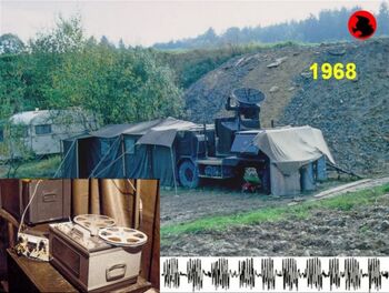

Military tracking radar “Superfledermaus” tracked single passerines up to 5 km; tracked pilot balloons provided wind data; photos of instruments with the three polar coordinates provided flight-path data; the birds’ headings and air-speeds were calculated from wind and bird tracks (Bruderer 1971, Bruderer & Steidinger 1972). – Echo-signa tures were recorded as modulated audio signals on tape to discriminate continuously flapping waterfowl and intermittently flapping passerines of differing size, and to eliminate bats and insects (Bruderer 1969, 1971). Radar sensitivity was calibrated by balloon-carried metal spheres (Bruderer & Joss 1969).
Migratory passage was quantified with a vertical beam and an additional low-elevation measurement (perpendicular to the principal direction of migration). The echoes appearing above the STC-threshold on the R-scope were first voice-recorded on tape. Later we used a continuously moving film to register the Z-modulated R-scope, the film strips showing 4 km range on the y-axis, and time on the x-axis: a) vertical beam high density migration, b) low density, c) low-elevation high density, d) small window with low density (Bruderer 1971).
1971-1980
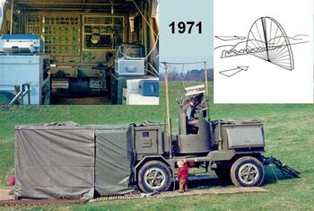
Photo-recording of the vertically scanning radar beam on the range-height indicator increased the surveyed space for quantification of migratory passage, but a rough data-analysis showed severe limitations of the method (Bruderer 1980). This prevented further use of the method (but did not prevent its use for recent ship radar studies). – Semi-digital recording of flight path by multiplex-pulse-length modulation of coordinates, the digitized signals transferred to a computer (Bloch & Bruderer 1981). – Improved echo-signature interpretation by recording tracks and echo-signatures of identified birds on video and audio track of video camera. Increasing the number of know wing-beat pattern by releasing birds by day and night into the radar beam (Bruderer et al. 1972, Bruderer & Neusser 1982).
1981-1990
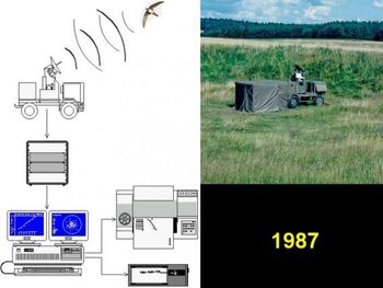
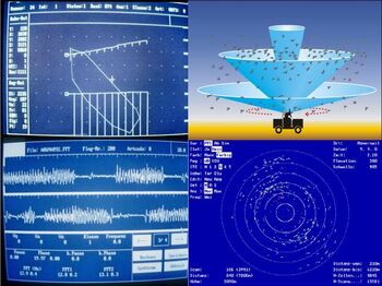
Radar studies in and around the Alps (Bruderer 1996), characterized by the combination of methods (Bruderer & Jenni 1990), and by the implementation of mini- and microcomputers. Studies with several radars in the approach area of the Alps (1987) with fully digitized system for recording of flight-paths, echo-signatures and the number of birds in conically scanning radar beam; flight-paths and echo-signatures simultaneously registered on traditional plotters as back-up (Bruderer et al. 1995).
Conical scanning at several angles was chosen as the standard method to measure the number and distribution of birds in a half-sphere of 6 km radius around the radar. Migration traffic rate (MTR) was obtained by multiplying the density (birds/km3) by the average ground-speed. Bruderer et al. (1995) demonstrated quantitatively the effect and compensation possibilities in detection probability with distance, elevation angle, and aspect.
1991-2000
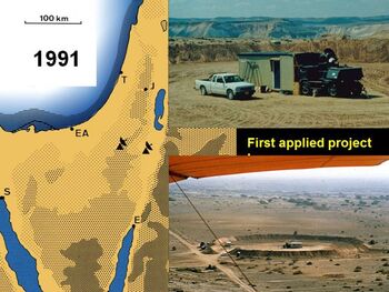
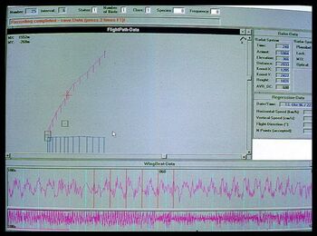
Radar studies in the eastern and western Mediterranean, including the first applied project, an environmental impact study for a planned antenna array of Voice of America in southern Israel (Bruderer 1999, Bruderer et al. 2000). Note the ideally constructed dams to protect the radar against ground clutter. Usually natural hollows served as radar locations (see corresponding images and publications mentioned above).
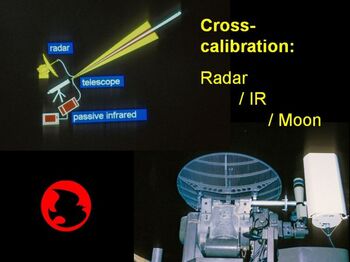
Cross-calibration of three counting systems (radar/passive infrared/moon-watching) allowed defining the effective beam-width of the radar as well as the silhouette size of birds at various ranges in the two optical systems (Liechti et al. 1995).
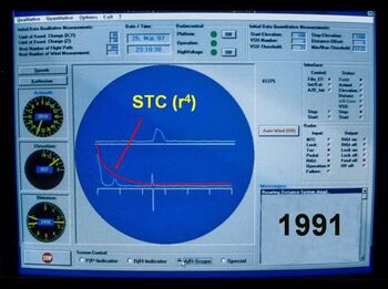
Quantification profited from the introduction of a mathematically exact STC to compensate for the R4-law up to 3 km range. The radar instruments for the three polar coordinates as well as the A- and R-scope presented real-time on the computer together with buttons allowing optimal target assessment and acquisition.
Presentation of electronically recorded flight-paths and echo-signatures brought to perfection (Bruderer et al. 2000). Note the projection of the track into the vertical and horizontal plane, and the wing-beat pattern on two time scales.1
2001 – 2010
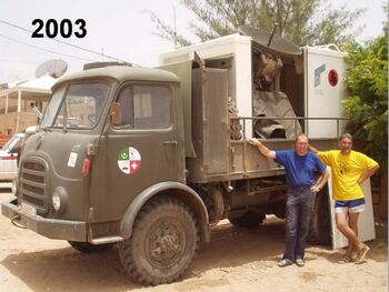
Studies on bird migration across the Sahara. While two fixed radar stations were used in the conventional way, new mobile radar was constructed to drive far into the desert. At the cost of lost tracking and scanning capability the weight of this mobile radar was reduced to less than one ton and the power consumption to 1 kW, the whole array together with the fully computerized and automatized recording system mounted on a 7-t truck. This radar system was the basis for all the following applications integrating marine radars with dish-antennas.
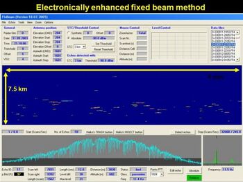
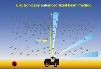
The MobiRad was one of the reasons to revive the old fixed-beam method. The other reason was to reach altitudes of 7.5 instead of 5 km with a fixed beam and improved receiver to cope with potential high flights above the desert. At the fixed radar stations (at the Mauritanian coast and next to an oasis 500 km inland) conical scanning and fixed-beam methods were used in parallel with tracking.
By digitally recording the intensity-variation of passing birds we obtain not only the temporal and vertical distribution of the targets (as with the photographic recording in 1968-1970), but additionally their individual echo-signatures, and all this in a form apt for electronic analysis (Schmaljohann et al. 2008).

Acknowledgments and references
The radars as well as considerable technical support were initially provided by Oerlikon-Contraves AG; later we obtained the radars on loan and eventually as a gift from the Swiss Army. The whole research formed part of the tasks of the Swiss Ornithological Institute, who invested millions of Swiss Francs in its migration department. From the beginning, most of the scientific projects were supported by the Swiss National Science Foundation, the Sahara project additionally by the Foundations Volkart, Vontobel, MAVA for Nature Protection, Ernst Göhner, Felis and Syngenta, the companies Bank Sarasin, Helvetia Patria Insurances and F. Hoffmann-La Roche AG, the European Science Foundation as well as BirdLife Switzerland and International. The first applied project was completely financed by the Israel Ministry of Communication. One of the recent applied projects, leading to the first operational individual of marine radar with a steerable pencil beam was supported by German Federal Ministry for the Environment.
A detailed reference list can be found in the attached pdf-files of publications on the history of the “Superfledermaus” (Bruderer 2007). More general papers on radar ornithology (Bruderer 1997a,b and Bruderer 2003) are also attached.
Would you like to know more about Swiss birdradar?
Read about the company today by clicking on the button below.
