Collision Risk Assessment Algorithm
Swiss Birdradar Solution has developed its collision risk assessment with adaptability in mind. Key parameters can be set based on local or federal laws or based on study results. Basis for the collision risk assessment are the Migration Traffic Rate (MTR) measurements from the radar. MTR is a scientifically standardized measurement counting the number of birds per hour that fly through a reference area. Roughly speaking the MTR represents how crowded the air space is. In addition to the MTR, the system can be configured to include sensor data like visibility or wind speeds in its collision risk assessment. This additional data can be obtained from the wind park or from sensors provided by Swiss Birdradar Solution.
The collision risk assessment algorithm can be configured with following parameters:
-
- Individual MTR limits for each wind turbine generator
- Configurable elevation intervals
- Exclusion of non-migratory fauna based on direction of flight
- Dynamic MTR limit adjustment based on various environmental factors like
- Time of day
- Visibility
- Windspeed
- Temperature
- Flight Direction
- …
With this adaptability, Swiss Birdradar Solution can tailor collision risk assessment to the needs of each site at a moment’s notice. For operators, this means shorter system setup times and reduced reaction times should regulations change in the future.
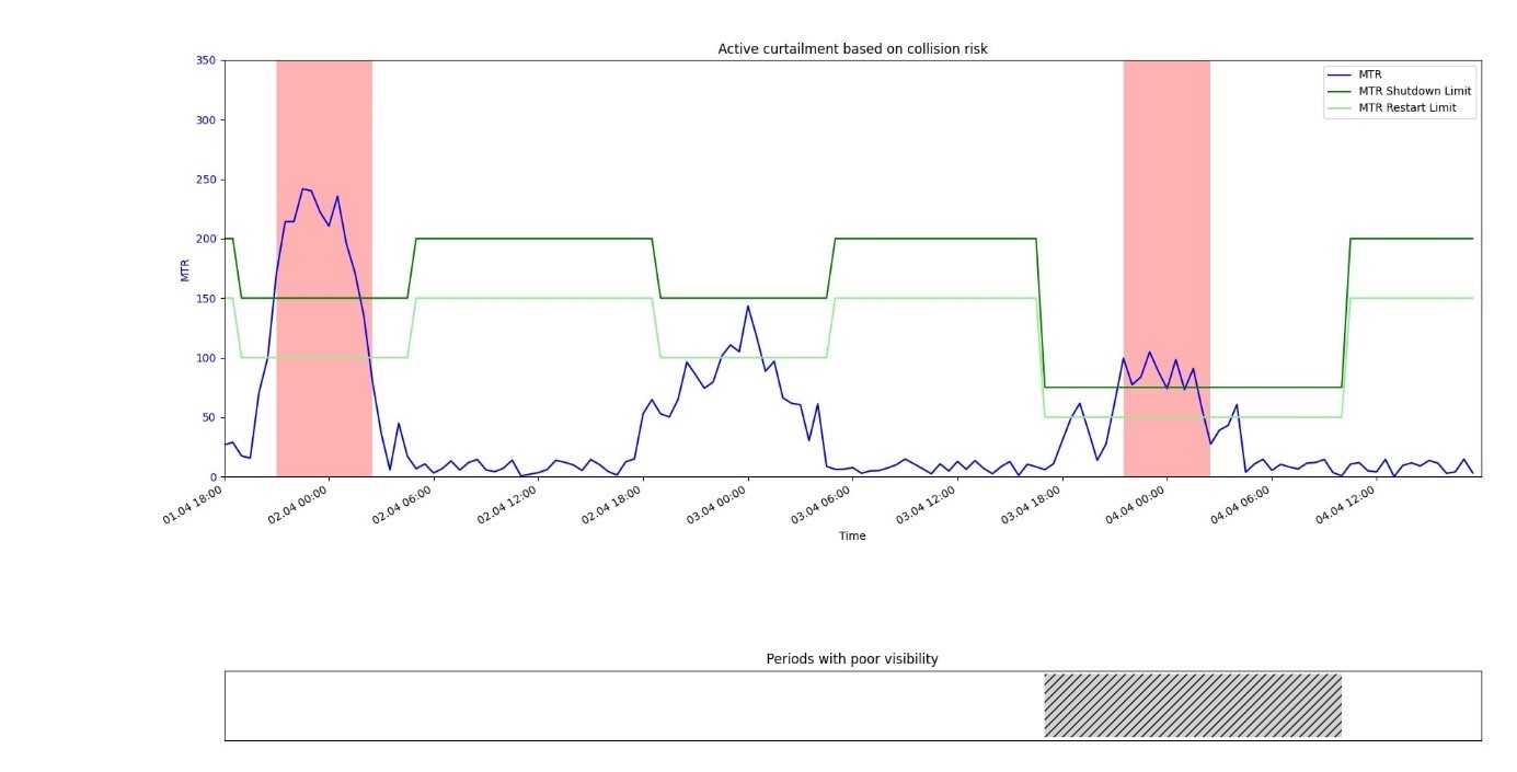
The graphic below shows how such a configuration can behave during migratory periods. Typically, high migratory traffic is recorded during the night while there is not much activity during the day. This is why in the example the peaks in MTR occur during the night.
Since visibility is better during day-time, the system parameters can be set to allow for higher MTR limits to avoid unnecessary shutdowns. Including data from visibility sensors can further decrease the need for restrictive MTR limits. Should the sensor detect poor visibility due to fog, the curtailment thresholds can be lowered automatically.

Short illustration of real-time curtailment. Shut-down (red) of the wind park during night-time migration peaks in spring (blue). Separate thresholds for day and night (green).
Are you looking for a radar solution?
Tell us about your project. We are looking forward to hearing from you.
